建築設計REPORT Vol.02
8/24
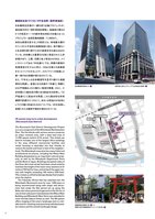
N日本橋三井タワー新日本橋駅三越前駅(半蔵門線)江戸桜通り大伝場本町通り日本橋浮世小路むろまち小路仲通りあじさい通り中央通り三越前駅(銀座線)(高速1号上野線)(高速都心環状線)室町東地区再開発三井別館三井二号館日本銀行本店三井本館三越本館三越新館1-5 街区福徳神社社務所(左) と再建予定の福徳神社のイメージ(VR:右)日本橋室町野村ビル室町東三井ビルディング(COREDO室町)継続的な街づくりにVRを活用(室町東地区)VR assists long-term urban development (Muromachi East District) 日本橋再生計画の一翼を担う主軸プロジェクトが、現在進行中の「室町東地区開発」。地権者の異なる5つの街区が一つの都市再生特区の対象となったプロジェクト(全街区敷地面積:11,900m2)。多彩な表情を見せるこの街区には、地域最大級のオフィスビルや多彩な商業施設に加え、街の賑わいと生活感を取り戻すための賃貸住宅も組み込まれている。日本橋には重要文化財に指定された三井本館があり、三越、日銀と並ぶ街並みがある。メインストリートである「中央通り」では、両側の建物の低層部高さを31mに抑え、100mを超える高層部をセットバックさせることで、スカイラインを意識した統一感のある景観が創り出されている。また、千年以上も日本橋室町を見守り続けた福徳神社を再建し、参道となる石畳の「仲通り」周囲には江戸情緒あふれた賑わい施設を整備。さらに、三井本館と三越本店の間にある桜並木を延伸し、「江戸桜通り」に桜並木を再現。これら複合的な将来構想の計画ひとつひとつ、あるいは街並みが全体としてどの様に形成されるかについても、VRを活用し、長期にわたる確認や検討が進められている。The Muromachi East District Development Project is a core component of the Nihonbashi Revitalization Plan. The five blocks with various owners comprise an urban renewal zone, with a total land area of 11,900 square meters (2.94 acres). This mixed use district includes one of the largest office buildings in the area, different commercial facilities and rental housing—a desirable mix that intends to restore the bustle and lived-in feel of the neighbor-hood. The Nihonbashi area also has many historical architectural structures, including the Mitsui Main Building designated as an important cultural prop-erty, as well as the Mitsukoshi Department Store and the Bank of Japan. Buildings along both sides of the Chuo-dori main street have been constructed to maintain the height of the lower story sections at 31 meters (102 feet) or less, and set back the upper sto-ries with heights exceeding 100 meters (328 feet). This creates a unified landscape design that empha-sizes the skyline.The Fukutoku Shrine that has watched over the Nihonbashi Muromachi area for over 1,000 years is being reconstructed along with shops and attrac-tions that evoke the Edo period set up along the Naka-dori stone pavement approach to the Shrine. A row of cherry blossom trees between the Mitsui Main Building and Mitsukoshi Main Store was extended to cover the Edo Sakura Street as well. The VR system offers imaging of the area’s landscape and is a reli-able tool for checking and examining individual proj-ect visions and the overall landscape design.日本橋街路図1122445537
元のページ